
Background/reasons for this initiative.
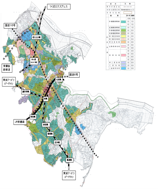
The city of Kashiwa has approximately 1,500 km of municipal roads, and the road infrastructure is only increasing as a result of ongoing road development and housing supply associated with land readjustment projects in the northern city area. Therefore, with a limited budget, it is an urgent task to establish an efficient road repair plan for roads, which are the social infrastructure with which citizens are most in contact.
However, the number of reports and requests concerning roads received from residents exceeds 3,500 per year (approximately 1,000 concerning road irregularities and repairs), and staff are forced to deal with them on a daily basis and deal with them individually.
The main reason for this is that the city developed rapidly as a bedroom town between 1965 and 1975, and it is difficult to quantitatively grasp the ever-changing condition of all roads, which has led to the current situation without a long-term repair plan being drawn up.
Figure1: Overall diagram of Kashiwa City
Period of implementation of the initiative
Oct 2014 – Mar 2015 (social experiment)
Ongoing from April 2015 (full-scale implementation)
Details of initiatives
In cooperation with Fujitsu Limited, which is also a member of the Kashiwa ITS Promotion Council, the measures listed in the table below were implemented in the ‘On-site demonstration of new road-related initiatives’ by the Kanto Regional Development Bureau of the Ministry of Land, Infrastructure and Transport. Specifically, a simple road surface survey was carried out using the Road Patrol Support Service (Note 1), the results of which were compared with MCI (Note 2) survey results, and the use of the results in dealing with local residents was also tested. (Note 1: Fujitsu’s simplified road surface diagnosis tool; Note 2: Maintenance Control Index: maintenance control index of pavements).
| (1) Identification of the compensated deterioration state by a simplified road surface survey using a smartphone and comparison with MCI. | |
|---|---|
| Expected effects. | Confirm that the simplified road surface survey using smartphones is a sufficiently practical measurement method as a simplified version of the road surface condition survey (MCI measurement) Expect an agreement rate of more than 80%; (3) Confirm that the road surface condition survey using smartphones is a sufficiently practical measurement method as a simplified version of the road surface condition survey (MCI measurement) Expect an agreement rate of more than 80%. |
| Result. | Roads on which MCI measurements were carried out in June 2013 were evaluated in a simplified road surface condition survey in December 2014. The agreement rate was 77.2%. |
| Assessment of results. | Four sections out of the 18 assessment periods were detected as having greater deterioration than the MCI measurements, but the results of the field survey showed that deterioration had progressed over the 18 months. From this, it was assessed that the functionality was similar to that of the MCI survey. |
| (2) Use of the results of the simplified road surface survey to address the needs of residents and verification of its effectiveness | |
|---|---|
| Expected effects. | Residents who request road repairs are given explanations on the feasibility of repairs and the details of the repair work based on the results of the simple deterioration diagnosis, and their understanding is obtained. The acceptance rate was set at 70%. |
| Result. | Explanations were given to 2 residents and 23 citizens and municipal road users who had actually requested repairs. 90% of the respondents stated that the materials were easy to understand and that fairness can be expected from these initiatives. |
| Evaluation of results | Ethical prioritisation of repairs and efficient repair procedures were appreciated by 90% of the respondents. The explanatory materials prepared in this study were evaluated as effective as explanatory materials for residents. However, it was also found that there is room for improvement of the materials. |
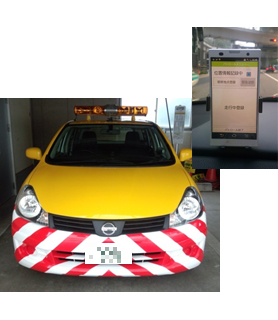
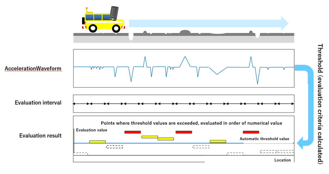
Figure-2: Image of a smartphone mounted and simple road surface survey system
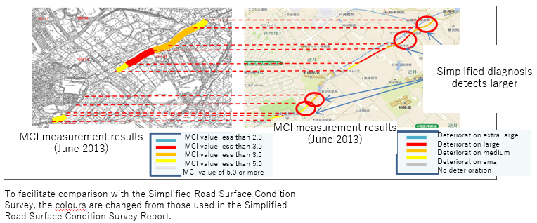
Figure-3: Comparison of MCI measurement results and simplified road surface condition survey results
Future issues and status of response
- (1) Simplified road surface survey
- In this simplified road surface survey, it is necessary to drive over the same area several times to calculate the evaluation index in order to ensure diagnostic accuracy. A new version of the system was introduced in June 2015 to automate the overlapping and visualise the entire municipal road.
- (2) Use for resident response
- The simple road surface survey uses a smartphone to measure the shaking of the vehicle and statistically process it to diagnose pavement deterioration, but to convince residents, materials are needed to explain the mechanism in an easy-to-understand manner.
- (3) Repair priorities
- The priority for repair is to give top priority to significant deterioration that could be a cause of accidents or liability for defects, while for the rest, the visualisation of the entire city road will be promoted and the repair priority will be decided, but it is necessary to organise the concept of repair priority based on a comprehensive assessment of the state of deterioration, residents’ complaints and other factors, and clarify the decision criteria.
Although there are many points that need to be improved through this social experiment, compared to MCI surveys, Kashiwa City has decided to continue using the simplified road surface survey from 2015 onwards because (1) it is overwhelmingly advantageous in terms of cost, (2) the evaluation can be immediately visualised and understood, and (3) the quantitative evaluation can be used to explain to residents. The city of Kashiwa has decided to continue using the simplified road surface survey from 2015 onwards, and is currently promoting the visualisation of city roads as a whole.
Figure-4: Status of visualisation of city roads (example)
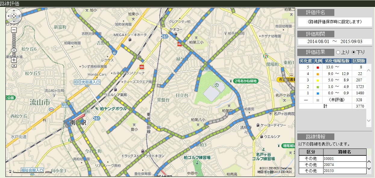
The maps on the right side of Figure-3 and Figure-4 are copyrighted by ZENRIN Corporation
Copyright2015 ZENRIN CO.,LTD. (Licence No. Z13LD No. 748)